|
|
|||||||||||||||||
| Point ID: 84 | Downloads | Plots | Site Data | Code: 05AD003 |
|
|
|||||||||||||||||
| Download | |
|---|---|
| Site Descriptor Information | Site Time Series Data |
| Link to all available data | |
| View: | Time Series | All |
| Units: | mm |
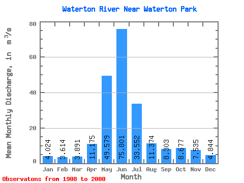
| Statistic | Jan | Feb | Mar | Apr | May | Jun | Jul | Aug | Sep | Oct | Nov | Dec | Annual |
|---|---|---|---|---|---|---|---|---|---|---|---|---|---|
| Mean | 4.02 | 3.61 | 3.89 | 11.18 | 49.58 | 75.80 | 33.55 | 11.37 | 8.30 | 8.68 | 7.54 | 4.84 | 18.14 |
| Standard Deviation | 1.78 | 1.36 | 1.86 | 5.49 | 12.57 | 28.16 | 14.86 | 4.07 | 5.61 | 6.04 | 4.91 | 2.65 | 3.89 |
| Min | 1.86 | 1.70 | 1.85 | 2.58 | 26.30 | 19.10 | 9.10 | 4.75 | 2.62 | 2.18 | 1.68 | 1.29 | 9.90 |
| Max | 11.00 | 8.62 | 12.60 | 31.30 | 84.30 | 171.00 | 69.10 | 22.20 | 35.60 | 30.10 | 25.60 | 16.20 | 27.73 |
| Coefficient of Variation | 0.44 | 0.38 | 0.48 | 0.49 | 0.25 | 0.37 | 0.44 | 0.36 | 0.68 | 0.70 | 0.65 | 0.55 | 0.21 |
 Return to R-Arctic Net Home Page