|
|
|||||||||||||||||
| Point ID: 84 | Downloads | Plots | Site Data | Code: 05AD003 |
|
|
|||||||||||||||||
| Download | |
|---|---|
| Site Descriptor Information | Site Time Series Data |
| Link to all available data | |
| View: | Time Series | All |
| Units: | m3/s |
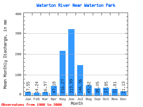
| Statistic | Jan | Feb | Mar | Apr | May | Jun | Jul | Aug | Sep | Oct | Nov | Dec | Annual |
|---|---|---|---|---|---|---|---|---|---|---|---|---|---|
| Mean | 17.55 | 14.36 | 16.97 | 47.18 | 216.24 | 320.00 | 146.34 | 49.61 | 35.05 | 37.85 | 31.81 | 21.13 | 932.19 |
| Standard Deviation | 7.74 | 5.41 | 8.11 | 23.19 | 54.84 | 118.89 | 64.79 | 17.73 | 23.68 | 26.33 | 20.73 | 11.57 | 199.80 |
| Min | 8.11 | 6.76 | 8.07 | 10.89 | 114.71 | 80.63 | 39.69 | 20.72 | 11.06 | 9.51 | 7.09 | 5.63 | 508.82 |
| Max | 47.98 | 34.26 | 54.96 | 132.13 | 367.68 | 721.88 | 301.38 | 96.83 | 150.28 | 131.28 | 108.07 | 70.66 | 1425.38 |
| Coefficient of Variation | 0.44 | 0.38 | 0.48 | 0.49 | 0.25 | 0.37 | 0.44 | 0.36 | 0.68 | 0.70 | 0.65 | 0.55 | 0.21 |
 Return to R-Arctic Net Home Page