|
|
|||||||||||||||||
| Point ID: 8371 | Downloads | Plots | Site Data | Code: 9418 |
|
|
|||||||||||||||||
| Download | |
|---|---|
| Site Descriptor Information | Site Time Series Data |
| Link to all available data | |
| View: | Time Series | All |
| Units: | mm |
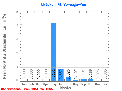
| Statistic | Jan | Feb | Mar | Apr | May | Jun | Jul | Aug | Sep | Oct | Nov | Dec | Annual |
|---|---|---|---|---|---|---|---|---|---|---|---|---|---|
| Mean | 0.00 | 0.00 | 0.00 | 0.00 | 4.15 | 0.85 | 0.32 | 0.11 | 0.13 | 0.14 | 0.03 | 0.01 | |
| Standard Deviation | 0.00 | 0.00 | 0.66 | 0.15 | 0.07 | 0.12 | 0.08 | 0.00 | 0.01 | ||||
| Min | 0.00 | 0.00 | 0.00 | 0.00 | 4.15 | 0.32 | 0.10 | 0.06 | 0.06 | 0.06 | 0.02 | 0.00 | |
| Max | 0.00 | 0.00 | 0.00 | 0.00 | 4.15 | 1.75 | 0.45 | 0.21 | 0.30 | 0.24 | 0.03 | 0.01 | |
| Coefficient of Variation | 0.77 | 0.48 | 0.65 | 0.88 | 0.57 | 0.08 | 1.18 |
 Return to R-Arctic Net Home Page