|
|
|||||||||||||||||
| Point ID: 8371 | Downloads | Plots | Site Data | Code: 9418 |
|
|
|||||||||||||||||
| Download | |
|---|---|
| Site Descriptor Information | Site Time Series Data |
| Link to all available data | |
| View: | Time Series | All |
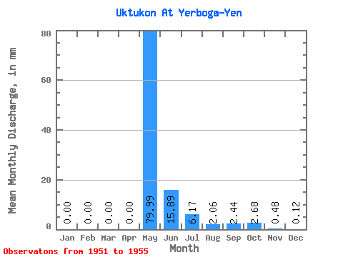
| Units: | m3/s |
| Statistic | Jan | Feb | Mar | Apr | May | Jun | Jul | Aug | Sep | Oct | Nov | Dec | Annual |
|---|---|---|---|---|---|---|---|---|---|---|---|---|---|
| Mean | 0.00 | 0.00 | 0.00 | 0.00 | 79.97 | 15.90 | 6.17 | 2.06 | 2.45 | 2.67 | 0.48 | 0.12 | |
| Standard Deviation | 0.00 | 0.00 | 12.23 | 2.98 | 1.35 | 2.15 | 1.52 | 0.04 | 0.14 | ||||
| Min | 0.00 | 0.00 | 0.00 | 0.00 | 79.97 | 5.97 | 1.93 | 1.10 | 1.04 | 1.23 | 0.45 | 0.02 | |
| Max | 0.00 | 0.00 | 0.00 | 0.00 | 79.97 | 32.63 | 8.67 | 4.05 | 5.59 | 4.62 | 0.50 | 0.21 | |
| Coefficient of Variation | 0.77 | 0.48 | 0.65 | 0.88 | 0.57 | 0.08 | 1.18 |
 Return to R-Arctic Net Home Page