|
|
|||||||||||||||||
| Point ID: 8366 | Downloads | Plots | Site Data | Code: 9391 |
|
|
|||||||||||||||||
| Download | |
|---|---|
| Site Descriptor Information | Site Time Series Data |
| Link to all available data | |
| View: | Time Series | All |
| Units: | mm |
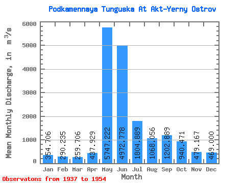
| Statistic | Jan | Feb | Mar | Apr | May | Jun | Jul | Aug | Sep | Oct | Nov | Dec | Annual |
|---|---|---|---|---|---|---|---|---|---|---|---|---|---|
| Mean | 354.71 | 290.24 | 259.71 | 437.93 | 5747.22 | 4972.78 | 1804.89 | 1068.06 | 1202.89 | 940.47 | 479.17 | 469.00 | 1651.26 |
| Standard Deviation | 103.01 | 74.95 | 69.52 | 351.27 | 2878.80 | 1550.12 | 616.22 | 319.61 | 381.51 | 304.18 | 171.77 | 148.80 | 159.36 |
| Min | 182.00 | 174.00 | 153.00 | 165.00 | 400.00 | 2610.00 | 938.00 | 551.00 | 611.00 | 418.00 | 110.00 | 215.00 | 1424.67 |
| Max | 635.00 | 495.00 | 437.00 | 1340.00 | 8840.00 | 8160.00 | 3060.00 | 1660.00 | 2060.00 | 1690.00 | 824.00 | 907.00 | 1949.00 |
| Coefficient of Variation | 0.29 | 0.26 | 0.27 | 0.80 | 0.50 | 0.31 | 0.34 | 0.30 | 0.32 | 0.32 | 0.36 | 0.32 | 0.10 |
 Return to R-Arctic Net Home Page