|
|
|||||||||||||||||
| Point ID: 8366 | Downloads | Plots | Site Data | Code: 9391 |
|
|
|||||||||||||||||
| Download | |
|---|---|
| Site Descriptor Information | Site Time Series Data |
| Link to all available data | |
| View: | Time Series | All |
| Units: | m3/s |
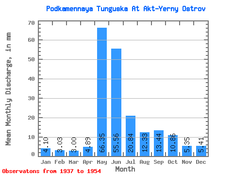
| Statistic | Jan | Feb | Mar | Apr | May | Jun | Jul | Aug | Sep | Oct | Nov | Dec | Annual |
|---|---|---|---|---|---|---|---|---|---|---|---|---|---|
| Mean | 4.09 | 3.05 | 3.00 | 4.89 | 66.34 | 55.56 | 20.83 | 12.33 | 13.44 | 10.86 | 5.35 | 5.41 | 224.63 |
| Standard Deviation | 1.19 | 0.79 | 0.80 | 3.92 | 33.23 | 17.32 | 7.11 | 3.69 | 4.26 | 3.51 | 1.92 | 1.72 | 21.68 |
| Min | 2.10 | 1.83 | 1.77 | 1.84 | 4.62 | 29.16 | 10.83 | 6.36 | 6.83 | 4.83 | 1.23 | 2.48 | 193.80 |
| Max | 7.33 | 5.21 | 5.04 | 14.97 | 102.04 | 91.17 | 35.32 | 19.16 | 23.02 | 19.51 | 9.21 | 10.47 | 265.13 |
| Coefficient of Variation | 0.29 | 0.26 | 0.27 | 0.80 | 0.50 | 0.31 | 0.34 | 0.30 | 0.32 | 0.32 | 0.36 | 0.32 | 0.10 |
 Return to R-Arctic Net Home Page