|
|
|||||||||||||||||
| Point ID: 8359 | Downloads | Plots | Site Data | Code: 9355 |
|
|
|||||||||||||||||
| Download | |
|---|---|
| Site Descriptor Information | Site Time Series Data |
| Link to all available data | |
| View: | Time Series | All |
| Units: | mm |
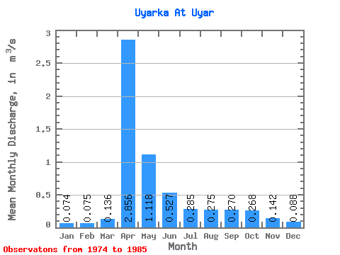
| Statistic | Jan | Feb | Mar | Apr | May | Jun | Jul | Aug | Sep | Oct | Nov | Dec | Annual |
|---|---|---|---|---|---|---|---|---|---|---|---|---|---|
| Mean | 0.07 | 0.07 | 0.14 | 2.86 | 1.12 | 0.53 | 0.28 | 0.28 | 0.27 | 0.27 | 0.14 | 0.09 | 0.51 |
| Standard Deviation | 0.04 | 0.03 | 0.11 | 1.08 | 0.57 | 0.31 | 0.13 | 0.10 | 0.10 | 0.09 | 0.04 | 0.03 | 0.14 |
| Min | 0.03 | 0.02 | 0.04 | 0.85 | 0.37 | 0.27 | 0.13 | 0.18 | 0.15 | 0.16 | 0.08 | 0.04 | 0.26 |
| Max | 0.14 | 0.14 | 0.39 | 5.22 | 2.17 | 1.25 | 0.59 | 0.49 | 0.52 | 0.47 | 0.21 | 0.14 | 0.81 |
| Coefficient of Variation | 0.50 | 0.43 | 0.84 | 0.38 | 0.51 | 0.58 | 0.45 | 0.36 | 0.38 | 0.33 | 0.30 | 0.31 | 0.27 |
 Return to R-Arctic Net Home Page