|
|
|||||||||||||||||
| Point ID: 8359 | Downloads | Plots | Site Data | Code: 9355 |
|
|
|||||||||||||||||
| Download | |
|---|---|
| Site Descriptor Information | Site Time Series Data |
| Link to all available data | |
| View: | Time Series | All |
| Units: | m3/s |
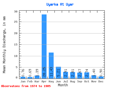
| Statistic | Jan | Feb | Mar | Apr | May | Jun | Jul | Aug | Sep | Oct | Nov | Dec | Annual |
|---|---|---|---|---|---|---|---|---|---|---|---|---|---|
| Mean | 0.75 | 0.70 | 1.39 | 28.25 | 11.43 | 5.22 | 2.91 | 2.82 | 2.67 | 2.74 | 1.41 | 0.90 | 61.48 |
| Standard Deviation | 0.38 | 0.30 | 1.17 | 10.70 | 5.84 | 3.03 | 1.31 | 1.02 | 1.02 | 0.89 | 0.43 | 0.28 | 16.73 |
| Min | 0.33 | 0.20 | 0.42 | 8.41 | 3.78 | 2.67 | 1.33 | 1.84 | 1.48 | 1.64 | 0.75 | 0.45 | 30.78 |
| Max | 1.43 | 1.30 | 3.99 | 51.65 | 22.18 | 12.37 | 6.03 | 5.01 | 5.14 | 4.80 | 2.08 | 1.43 | 97.80 |
| Coefficient of Variation | 0.50 | 0.43 | 0.84 | 0.38 | 0.51 | 0.58 | 0.45 | 0.36 | 0.38 | 0.33 | 0.30 | 0.31 | 0.27 |
 Return to R-Arctic Net Home Page