|
|
|||||||||||||||||
| Point ID: 8351 | Downloads | Plots | Site Data | Code: 9320 |
|
|
|||||||||||||||||
| Download | |
|---|---|
| Site Descriptor Information | Site Time Series Data |
| Link to all available data | |
| View: | Time Series | All |
| Units: | mm |
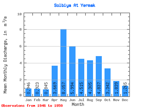
| Statistic | Jan | Feb | Mar | Apr | May | Jun | Jul | Aug | Sep | Oct | Nov | Dec | Annual |
|---|---|---|---|---|---|---|---|---|---|---|---|---|---|
| Mean | 0.95 | 0.92 | 0.84 | 3.67 | 8.06 | 5.99 | 4.51 | 4.30 | 4.84 | 3.34 | 1.84 | 1.27 | 3.37 |
| Standard Deviation | 0.33 | 0.27 | 0.24 | 1.74 | 2.79 | 1.44 | 1.62 | 1.43 | 2.16 | 1.07 | 0.60 | 0.52 | 0.48 |
| Min | 0.40 | 0.51 | 0.44 | 1.61 | 4.34 | 3.23 | 2.43 | 2.13 | 2.14 | 1.86 | 1.12 | 0.84 | 2.83 |
| Max | 1.60 | 1.51 | 1.18 | 7.39 | 12.50 | 8.22 | 7.58 | 6.87 | 9.42 | 5.75 | 3.34 | 2.46 | 4.36 |
| Coefficient of Variation | 0.35 | 0.29 | 0.28 | 0.47 | 0.35 | 0.24 | 0.36 | 0.33 | 0.45 | 0.32 | 0.33 | 0.41 | 0.14 |
 Return to R-Arctic Net Home Page