|
|
|||||||||||||||||
| Point ID: 8351 | Downloads | Plots | Site Data | Code: 9320 |
|
|
|||||||||||||||||
| Download | |
|---|---|
| Site Descriptor Information | Site Time Series Data |
| Link to all available data | |
| View: | Time Series | All |
| Units: | m3/s |
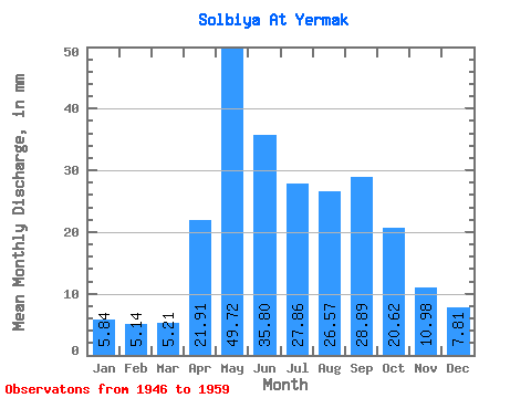
| Statistic | Jan | Feb | Mar | Apr | May | Jun | Jul | Aug | Sep | Oct | Nov | Dec | Annual |
|---|---|---|---|---|---|---|---|---|---|---|---|---|---|
| Mean | 5.83 | 5.19 | 5.21 | 21.91 | 49.72 | 35.80 | 27.86 | 26.56 | 28.89 | 20.62 | 10.98 | 7.80 | 245.03 |
| Standard Deviation | 2.02 | 1.53 | 1.48 | 10.37 | 17.22 | 8.60 | 9.99 | 8.84 | 12.89 | 6.62 | 3.58 | 3.19 | 35.12 |
| Min | 2.47 | 2.87 | 2.71 | 9.62 | 26.78 | 19.29 | 14.99 | 13.14 | 12.78 | 11.48 | 6.69 | 5.18 | 205.85 |
| Max | 9.87 | 8.49 | 7.29 | 44.14 | 77.13 | 49.09 | 46.77 | 42.39 | 56.26 | 35.48 | 19.95 | 15.18 | 316.93 |
| Coefficient of Variation | 0.35 | 0.29 | 0.28 | 0.47 | 0.35 | 0.24 | 0.36 | 0.33 | 0.45 | 0.32 | 0.33 | 0.41 | 0.14 |
 Return to R-Arctic Net Home Page