|
|
|||||||||||||||||
| Point ID: 8338 | Downloads | Plots | Site Data | Code: 9299 |
|
|
|||||||||||||||||
| Download | |
|---|---|
| Site Descriptor Information | Site Time Series Data |
| Link to all available data | |
| View: | Time Series | All |
| Units: | mm |
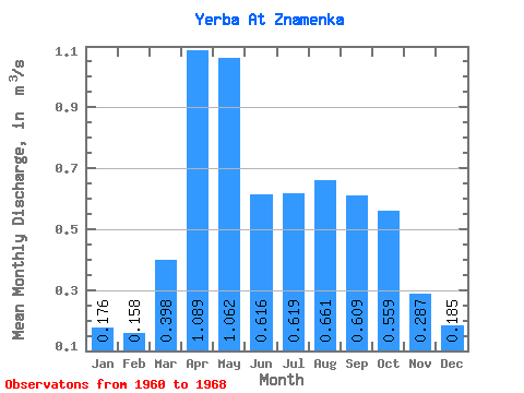
| Statistic | Jan | Feb | Mar | Apr | May | Jun | Jul | Aug | Sep | Oct | Nov | Dec | Annual |
|---|---|---|---|---|---|---|---|---|---|---|---|---|---|
| Mean | 0.18 | 0.16 | 0.40 | 1.09 | 1.06 | 0.62 | 0.62 | 0.66 | 0.61 | 0.56 | 0.29 | 0.18 | 0.53 |
| Standard Deviation | 0.05 | 0.08 | 0.31 | 0.39 | 0.85 | 0.26 | 0.34 | 0.26 | 0.23 | 0.25 | 0.10 | 0.06 | 0.16 |
| Min | 0.09 | 0.03 | 0.04 | 0.58 | 0.41 | 0.19 | 0.08 | 0.19 | 0.39 | 0.18 | 0.13 | 0.12 | 0.25 |
| Max | 0.26 | 0.31 | 1.17 | 1.62 | 3.21 | 0.90 | 1.22 | 1.02 | 1.01 | 0.86 | 0.41 | 0.30 | 0.68 |
| Coefficient of Variation | 0.30 | 0.53 | 0.78 | 0.36 | 0.80 | 0.43 | 0.54 | 0.39 | 0.37 | 0.45 | 0.33 | 0.31 | 0.30 |
 Return to R-Arctic Net Home Page