|
|
|||||||||||||||||
| Point ID: 8338 | Downloads | Plots | Site Data | Code: 9299 |
|
|
|||||||||||||||||
| Download | |
|---|---|
| Site Descriptor Information | Site Time Series Data |
| Link to all available data | |
| View: | Time Series | All |
| Units: | m3/s |
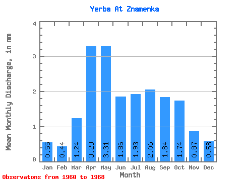
| Statistic | Jan | Feb | Mar | Apr | May | Jun | Jul | Aug | Sep | Oct | Nov | Dec | Annual |
|---|---|---|---|---|---|---|---|---|---|---|---|---|---|
| Mean | 0.55 | 0.45 | 1.24 | 3.29 | 3.31 | 1.86 | 1.93 | 2.06 | 1.84 | 1.74 | 0.87 | 0.58 | 19.50 |
| Standard Deviation | 0.17 | 0.24 | 0.97 | 1.18 | 2.66 | 0.80 | 1.05 | 0.80 | 0.69 | 0.78 | 0.29 | 0.18 | 5.83 |
| Min | 0.29 | 0.09 | 0.11 | 1.75 | 1.28 | 0.57 | 0.25 | 0.59 | 1.18 | 0.56 | 0.39 | 0.37 | 9.13 |
| Max | 0.81 | 0.88 | 3.65 | 4.89 | 10.01 | 2.72 | 3.80 | 3.18 | 3.05 | 2.68 | 1.24 | 0.94 | 24.94 |
| Coefficient of Variation | 0.30 | 0.53 | 0.78 | 0.36 | 0.80 | 0.43 | 0.54 | 0.39 | 0.37 | 0.45 | 0.33 | 0.31 | 0.30 |
 Return to R-Arctic Net Home Page