|
|
|||||||||||||||||
| Point ID: 8337 | Downloads | Plots | Site Data | Code: 9298 |
|
|
|||||||||||||||||
| Download | |
|---|---|
| Site Descriptor Information | Site Time Series Data |
| Link to all available data | |
| View: | Time Series | All |
| Units: | mm |
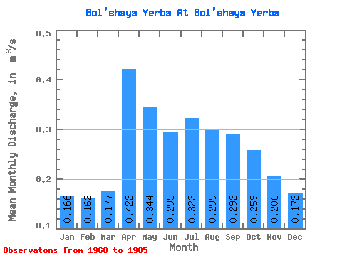
| Statistic | Jan | Feb | Mar | Apr | May | Jun | Jul | Aug | Sep | Oct | Nov | Dec | Annual |
|---|---|---|---|---|---|---|---|---|---|---|---|---|---|
| Mean | 0.17 | 0.16 | 0.18 | 0.42 | 0.34 | 0.29 | 0.32 | 0.30 | 0.29 | 0.26 | 0.21 | 0.17 | 0.26 |
| Standard Deviation | 0.05 | 0.05 | 0.06 | 0.16 | 0.08 | 0.07 | 0.12 | 0.10 | 0.09 | 0.06 | 0.05 | 0.05 | 0.06 |
| Min | 0.09 | 0.10 | 0.10 | 0.26 | 0.21 | 0.17 | 0.18 | 0.12 | 0.17 | 0.18 | 0.15 | 0.10 | 0.17 |
| Max | 0.26 | 0.26 | 0.31 | 0.79 | 0.55 | 0.44 | 0.69 | 0.55 | 0.52 | 0.43 | 0.36 | 0.30 | 0.37 |
| Coefficient of Variation | 0.32 | 0.29 | 0.33 | 0.38 | 0.23 | 0.25 | 0.37 | 0.33 | 0.30 | 0.22 | 0.26 | 0.29 | 0.23 |
 Return to R-Arctic Net Home Page