|
|
|||||||||||||||||
| Point ID: 8337 | Downloads | Plots | Site Data | Code: 9298 |
|
|
|||||||||||||||||
| Download | |
|---|---|
| Site Descriptor Information | Site Time Series Data |
| Link to all available data | |
| View: | Time Series | All |
| Units: | m3/s |
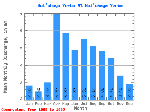
| Statistic | Jan | Feb | Mar | Apr | May | Jun | Jul | Aug | Sep | Oct | Nov | Dec | Annual |
|---|---|---|---|---|---|---|---|---|---|---|---|---|---|
| Mean | 2.84 | 2.52 | 3.02 | 6.96 | 5.87 | 4.87 | 5.50 | 5.11 | 4.82 | 4.42 | 3.41 | 2.94 | 52.30 |
| Standard Deviation | 0.90 | 0.74 | 0.98 | 2.65 | 1.37 | 1.22 | 2.01 | 1.69 | 1.46 | 0.97 | 0.89 | 0.86 | 12.18 |
| Min | 1.55 | 1.52 | 1.67 | 4.29 | 3.58 | 2.81 | 3.07 | 2.05 | 2.81 | 3.07 | 2.48 | 1.71 | 34.27 |
| Max | 4.43 | 4.04 | 5.29 | 13.04 | 9.38 | 7.26 | 11.77 | 9.38 | 8.59 | 7.33 | 5.94 | 5.12 | 75.22 |
| Coefficient of Variation | 0.32 | 0.29 | 0.33 | 0.38 | 0.23 | 0.25 | 0.37 | 0.33 | 0.30 | 0.22 | 0.26 | 0.29 | 0.23 |
 Return to R-Arctic Net Home Page