|
|
|||||||||||||||||
| Point ID: 8336 | Downloads | Plots | Site Data | Code: 9297 |
|
|
|||||||||||||||||
| Download | |
|---|---|
| Site Descriptor Information | Site Time Series Data |
| Link to all available data | |
| View: | Time Series | All |
| Units: | mm |
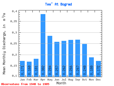
| Statistic | Jan | Feb | Mar | Apr | May | Jun | Jul | Aug | Sep | Oct | Nov | Dec | Annual |
|---|---|---|---|---|---|---|---|---|---|---|---|---|---|
| Mean | 0.17 | 0.17 | 0.18 | 0.38 | 0.28 | 0.26 | 0.26 | 0.27 | 0.27 | 0.25 | 0.19 | 0.17 | 0.23 |
| Standard Deviation | 0.12 | 0.11 | 0.11 | 0.19 | 0.10 | 0.10 | 0.10 | 0.09 | 0.12 | 0.12 | 0.12 | 0.14 | 0.09 |
| Min | 0.00 | 0.00 | 0.00 | 0.17 | 0.15 | 0.09 | 0.13 | 0.14 | 0.14 | 0.11 | 0.07 | 0.00 | 0.13 |
| Max | 0.59 | 0.54 | 0.52 | 1.00 | 0.49 | 0.48 | 0.52 | 0.48 | 0.79 | 0.76 | 0.78 | 0.76 | 0.51 |
| Coefficient of Variation | 0.69 | 0.68 | 0.59 | 0.50 | 0.36 | 0.40 | 0.39 | 0.34 | 0.47 | 0.50 | 0.67 | 0.81 | 0.40 |
 Return to R-Arctic Net Home Page