|
|
|||||||||||||||||
| Point ID: 8336 | Downloads | Plots | Site Data | Code: 9297 |
|
|
|||||||||||||||||
| Download | |
|---|---|
| Site Descriptor Information | Site Time Series Data |
| Link to all available data | |
| View: | Time Series | All |
| Units: | m3/s |
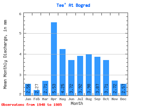
| Statistic | Jan | Feb | Mar | Apr | May | Jun | Jul | Aug | Sep | Oct | Nov | Dec | Annual |
|---|---|---|---|---|---|---|---|---|---|---|---|---|---|
| Mean | 2.56 | 2.29 | 2.71 | 5.53 | 4.25 | 3.72 | 3.92 | 3.98 | 3.87 | 3.72 | 2.73 | 2.57 | 40.34 |
| Standard Deviation | 1.78 | 1.56 | 1.60 | 2.79 | 1.53 | 1.50 | 1.51 | 1.34 | 1.81 | 1.86 | 1.82 | 2.07 | 15.97 |
| Min | 0.00 | 0.00 | 0.00 | 2.46 | 2.24 | 1.36 | 1.94 | 2.10 | 2.03 | 1.65 | 0.98 | 0.04 | 22.14 |
| Max | 8.83 | 7.36 | 7.78 | 14.48 | 7.33 | 6.95 | 7.78 | 7.18 | 11.44 | 11.37 | 11.29 | 11.37 | 89.92 |
| Coefficient of Variation | 0.69 | 0.68 | 0.59 | 0.50 | 0.36 | 0.40 | 0.39 | 0.34 | 0.47 | 0.50 | 0.67 | 0.81 | 0.40 |
 Return to R-Arctic Net Home Page