|
|
|||||||||||||||||
| Point ID: 8329 | Downloads | Plots | Site Data | Code: 9276 |
|
|
|||||||||||||||||
| Download | |
|---|---|
| Site Descriptor Information | Site Time Series Data |
| Link to all available data | |
| View: | Time Series | All |
| Units: | mm |
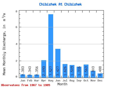
| Statistic | Jan | Feb | Mar | Apr | May | Jun | Jul | Aug | Sep | Oct | Nov | Dec | Annual |
|---|---|---|---|---|---|---|---|---|---|---|---|---|---|
| Mean | 0.38 | 0.34 | 0.36 | 2.09 | 7.53 | 3.43 | 1.63 | 1.51 | 1.32 | 1.56 | 0.80 | 0.49 | 1.77 |
| Standard Deviation | 0.09 | 0.08 | 0.08 | 1.22 | 3.19 | 1.38 | 0.83 | 0.99 | 0.76 | 0.81 | 0.34 | 0.13 | 0.45 |
| Min | 0.19 | 0.20 | 0.21 | 0.50 | 2.96 | 1.29 | 0.75 | 0.45 | 0.59 | 0.45 | 0.36 | 0.27 | 1.00 |
| Max | 0.54 | 0.48 | 0.51 | 4.49 | 15.70 | 5.27 | 3.71 | 3.93 | 3.44 | 3.44 | 1.46 | 0.66 | 2.37 |
| Coefficient of Variation | 0.24 | 0.23 | 0.22 | 0.58 | 0.42 | 0.40 | 0.51 | 0.66 | 0.57 | 0.52 | 0.43 | 0.27 | 0.25 |
 Return to R-Arctic Net Home Page