|
|
|||||||||||||||||
| Point ID: 8329 | Downloads | Plots | Site Data | Code: 9276 |
|
|
|||||||||||||||||
| Download | |
|---|---|
| Site Descriptor Information | Site Time Series Data |
| Link to all available data | |
| View: | Time Series | All |
| Units: | m3/s |
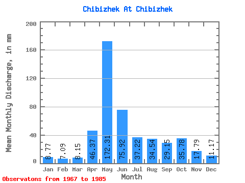
| Statistic | Jan | Feb | Mar | Apr | May | Jun | Jul | Aug | Sep | Oct | Nov | Dec | Annual |
|---|---|---|---|---|---|---|---|---|---|---|---|---|---|
| Mean | 8.76 | 7.16 | 8.16 | 46.36 | 172.29 | 75.92 | 37.23 | 34.54 | 29.15 | 35.77 | 17.79 | 11.18 | 478.22 |
| Standard Deviation | 2.12 | 1.66 | 1.77 | 27.06 | 73.08 | 30.55 | 18.95 | 22.68 | 16.73 | 18.50 | 7.62 | 3.06 | 120.34 |
| Min | 4.35 | 4.17 | 4.81 | 11.08 | 67.75 | 28.58 | 17.17 | 10.30 | 13.07 | 10.30 | 7.97 | 6.18 | 270.64 |
| Max | 12.36 | 10.01 | 11.67 | 99.47 | 359.36 | 116.75 | 84.92 | 89.95 | 76.21 | 78.74 | 32.34 | 15.11 | 638.41 |
| Coefficient of Variation | 0.24 | 0.23 | 0.22 | 0.58 | 0.42 | 0.40 | 0.51 | 0.66 | 0.57 | 0.52 | 0.43 | 0.27 | 0.25 |
 Return to R-Arctic Net Home Page