|
|
|||||||||||||||||
| Point ID: 8327 | Downloads | Plots | Site Data | Code: 9267 |
|
|
|||||||||||||||||
| Download | |
|---|---|
| Site Descriptor Information | Site Time Series Data |
| Link to all available data | |
| View: | Time Series | All |
| Units: | mm |
| Statistic | Jan | Feb | Mar | Apr | May | Jun | Jul | Aug | Sep | Oct | Nov | Dec | Annual |
|---|---|---|---|---|---|---|---|---|---|---|---|---|---|
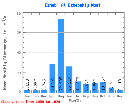
| Mean | 2.62 | 2.36 | 2.75 | 28.92 | 72.91 | 26.21 | 11.38 | 8.89 | 9.56 | 10.56 | 5.19 | 3.11 | 15.27 |
| Standard Deviation | 0.56 | 0.65 | 0.68 | 11.30 | 27.48 | 14.35 | 6.38 | 5.28 | 7.69 | 5.71 | 2.28 | 0.71 | 3.33 |
| Min | 1.70 | 1.41 | 1.53 | 10.60 | 32.40 | 10.20 | 5.15 | 3.04 | 3.87 | 2.81 | 2.09 | 2.00 | 10.08 |
| Max | 3.54 | 4.19 | 4.34 | 49.30 | 139.00 | 69.90 | 31.10 | 25.50 | 38.70 | 22.80 | 11.60 | 4.39 | 22.01 |
| Coefficient of Variation | 0.21 | 0.27 | 0.25 | 0.39 | 0.38 | 0.55 | 0.56 | 0.59 | 0.81 | 0.54 | 0.44 | 0.23 | 0.22 |
 Return to R-Arctic Net Home Page