|
|
|||||||||||||||||
| Point ID: 8327 | Downloads | Plots | Site Data | Code: 9267 |
|
|
|||||||||||||||||
| Download | |
|---|---|
| Site Descriptor Information | Site Time Series Data |
| Link to all available data | |
| View: | Time Series | All |
| Units: | m3/s |
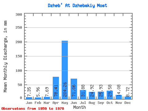
| Statistic | Jan | Feb | Mar | Apr | May | Jun | Jul | Aug | Sep | Oct | Nov | Dec | Annual |
|---|---|---|---|---|---|---|---|---|---|---|---|---|---|
| Mean | 7.35 | 6.01 | 7.69 | 78.41 | 204.23 | 71.06 | 31.87 | 24.91 | 25.92 | 29.57 | 14.08 | 8.72 | 504.18 |
| Standard Deviation | 1.56 | 1.65 | 1.92 | 30.63 | 76.98 | 38.90 | 17.87 | 14.80 | 20.86 | 15.99 | 6.19 | 1.99 | 109.80 |
| Min | 4.76 | 3.60 | 4.29 | 28.74 | 90.76 | 27.66 | 14.43 | 8.52 | 10.49 | 7.87 | 5.67 | 5.60 | 332.68 |
| Max | 9.92 | 10.69 | 12.16 | 133.67 | 389.37 | 189.52 | 87.12 | 71.43 | 104.93 | 63.87 | 31.45 | 12.30 | 726.63 |
| Coefficient of Variation | 0.21 | 0.27 | 0.25 | 0.39 | 0.38 | 0.55 | 0.56 | 0.59 | 0.81 | 0.54 | 0.44 | 0.23 | 0.22 |
 Return to R-Arctic Net Home Page