|
|
|||||||||||||||||
| Point ID: 8321 | Downloads | Plots | Site Data | Code: 9232 |
|
|
|||||||||||||||||
| Download | |
|---|---|
| Site Descriptor Information | Site Time Series Data |
| Link to all available data | |
| View: | Time Series | All |
| Units: | mm |
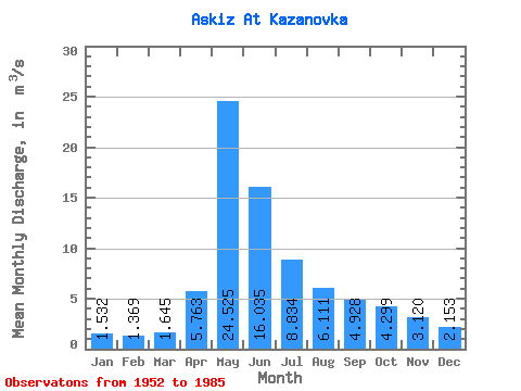
| Statistic | Jan | Feb | Mar | Apr | May | Jun | Jul | Aug | Sep | Oct | Nov | Dec | Annual |
|---|---|---|---|---|---|---|---|---|---|---|---|---|---|
| Mean | 1.53 | 1.37 | 1.65 | 5.76 | 24.52 | 16.04 | 8.83 | 6.11 | 4.93 | 4.30 | 3.12 | 2.15 | 6.66 |
| Standard Deviation | 0.43 | 0.51 | 0.43 | 2.37 | 9.13 | 7.79 | 3.31 | 2.03 | 1.59 | 1.02 | 0.85 | 0.58 | 1.52 |
| Min | 0.67 | 0.25 | 0.28 | 2.20 | 6.85 | 6.56 | 3.92 | 2.76 | 3.10 | 2.99 | 1.83 | 1.41 | 4.18 |
| Max | 2.33 | 2.51 | 2.25 | 10.10 | 50.50 | 35.70 | 17.30 | 11.30 | 11.00 | 7.17 | 5.32 | 3.87 | 10.76 |
| Coefficient of Variation | 0.28 | 0.37 | 0.26 | 0.41 | 0.37 | 0.49 | 0.37 | 0.33 | 0.32 | 0.24 | 0.27 | 0.27 | 0.23 |
 Return to R-Arctic Net Home Page