|
|
|||||||||||||||||
| Point ID: 8321 | Downloads | Plots | Site Data | Code: 9232 |
|
|
|||||||||||||||||
| Download | |
|---|---|
| Site Descriptor Information | Site Time Series Data |
| Link to all available data | |
| View: | Time Series | All |
| Units: | m3/s |
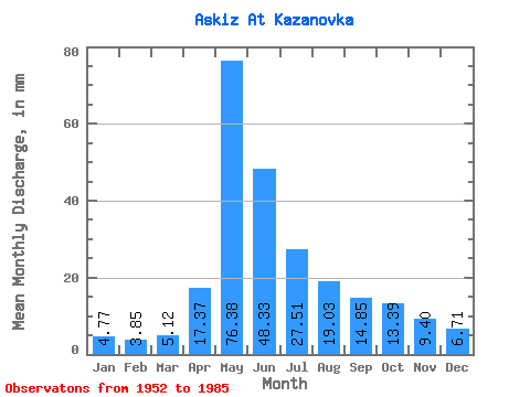
| Statistic | Jan | Feb | Mar | Apr | May | Jun | Jul | Aug | Sep | Oct | Nov | Dec | Annual |
|---|---|---|---|---|---|---|---|---|---|---|---|---|---|
| Mean | 4.77 | 3.88 | 5.12 | 17.37 | 76.37 | 48.33 | 27.51 | 19.03 | 14.85 | 13.38 | 9.40 | 6.71 | 244.50 |
| Standard Deviation | 1.35 | 1.44 | 1.35 | 7.15 | 28.43 | 23.48 | 10.30 | 6.32 | 4.81 | 3.17 | 2.56 | 1.82 | 55.73 |
| Min | 2.09 | 0.71 | 0.87 | 6.63 | 21.33 | 19.77 | 12.21 | 8.60 | 9.34 | 9.31 | 5.52 | 4.39 | 153.58 |
| Max | 7.26 | 7.12 | 7.01 | 30.44 | 157.25 | 107.60 | 53.87 | 35.19 | 33.15 | 22.33 | 16.03 | 12.05 | 394.68 |
| Coefficient of Variation | 0.28 | 0.37 | 0.26 | 0.41 | 0.37 | 0.49 | 0.37 | 0.33 | 0.32 | 0.24 | 0.27 | 0.27 | 0.23 |
 Return to R-Arctic Net Home Page