|
|
|||||||||||||||||
| Point ID: 8320 | Downloads | Plots | Site Data | Code: 9231 |
|
|
|||||||||||||||||
| Download | |
|---|---|
| Site Descriptor Information | Site Time Series Data |
| Link to all available data | |
| View: | Time Series | All |
| Units: | mm |
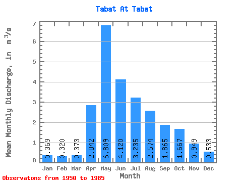
| Statistic | Jan | Feb | Mar | Apr | May | Jun | Jul | Aug | Sep | Oct | Nov | Dec | Annual |
|---|---|---|---|---|---|---|---|---|---|---|---|---|---|
| Mean | 0.37 | 0.32 | 0.37 | 2.84 | 6.81 | 4.12 | 3.23 | 2.57 | 1.86 | 1.67 | 0.95 | 0.53 | 2.15 |
| Standard Deviation | 0.12 | 0.13 | 0.17 | 1.48 | 3.37 | 2.28 | 3.45 | 2.18 | 0.98 | 1.05 | 0.50 | 0.19 | 0.73 |
| Min | 0.14 | 0.06 | 0.06 | 0.64 | 2.65 | 0.95 | 0.67 | 0.40 | 0.49 | 0.47 | 0.34 | 0.19 | 0.94 |
| Max | 0.67 | 0.62 | 0.81 | 5.92 | 15.10 | 11.60 | 14.10 | 10.20 | 4.83 | 5.81 | 2.37 | 1.06 | 3.93 |
| Coefficient of Variation | 0.32 | 0.40 | 0.44 | 0.52 | 0.49 | 0.55 | 1.06 | 0.85 | 0.53 | 0.63 | 0.53 | 0.35 | 0.34 |
 Return to R-Arctic Net Home Page