|
|
|||||||||||||||||
| Point ID: 8320 | Downloads | Plots | Site Data | Code: 9231 |
|
|
|||||||||||||||||
| Download | |
|---|---|
| Site Descriptor Information | Site Time Series Data |
| Link to all available data | |
| View: | Time Series | All |
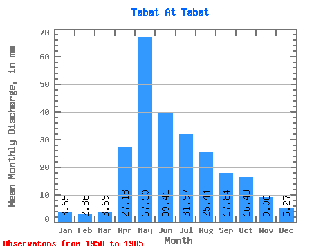
| Units: | m3/s |
| Statistic | Jan | Feb | Mar | Apr | May | Jun | Jul | Aug | Sep | Oct | Nov | Dec | Annual |
|---|---|---|---|---|---|---|---|---|---|---|---|---|---|
| Mean | 3.65 | 2.88 | 3.69 | 27.19 | 67.29 | 39.40 | 31.97 | 25.44 | 17.84 | 16.47 | 9.08 | 5.26 | 250.01 |
| Standard Deviation | 1.17 | 1.15 | 1.64 | 14.15 | 33.33 | 21.78 | 34.06 | 21.57 | 9.41 | 10.39 | 4.76 | 1.86 | 85.29 |
| Min | 1.39 | 0.57 | 0.58 | 6.12 | 26.19 | 9.09 | 6.62 | 3.95 | 4.69 | 4.64 | 3.25 | 1.88 | 109.37 |
| Max | 6.62 | 5.58 | 8.00 | 56.62 | 149.22 | 110.95 | 139.34 | 100.80 | 46.20 | 57.41 | 22.67 | 10.47 | 457.97 |
| Coefficient of Variation | 0.32 | 0.40 | 0.44 | 0.52 | 0.49 | 0.55 | 1.06 | 0.85 | 0.53 | 0.63 | 0.53 | 0.35 | 0.34 |
 Return to R-Arctic Net Home Page