|
|
|||||||||||||||||
| Point ID: 8307 | Downloads | Plots | Site Data | Code: 9184 |
|
|
|||||||||||||||||
| Download | |
|---|---|
| Site Descriptor Information | Site Time Series Data |
| Link to all available data | |
| View: | Time Series | All |
| Units: | mm |
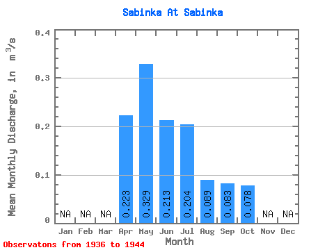
| Statistic | Jan | Feb | Mar | Apr | May | Jun | Jul | Aug | Sep | Oct | Nov | Dec | Annual |
|---|---|---|---|---|---|---|---|---|---|---|---|---|---|
| Mean | 0.22 | 0.33 | 0.21 | 0.20 | 0.09 | 0.08 | 0.08 | ||||||
| Standard Deviation | 0.09 | 0.17 | 0.16 | 0.17 | 0.06 | 0.05 | 0.04 | ||||||
| Min | 0.15 | 0.16 | 0.09 | 0.02 | 0.01 | 0.01 | 0.00 | ||||||
| Max | 0.33 | 0.65 | 0.59 | 0.50 | 0.22 | 0.17 | 0.14 | ||||||
| Coefficient of Variation | 0.40 | 0.51 | 0.73 | 0.85 | 0.72 | 0.60 | 0.55 |
 Return to R-Arctic Net Home Page