|
|
|||||||||||||||||
| Point ID: 8307 | Downloads | Plots | Site Data | Code: 9184 |
|
|
|||||||||||||||||
| Download | |
|---|---|
| Site Descriptor Information | Site Time Series Data |
| Link to all available data | |
| View: | Time Series | All |
| Units: | m3/s |
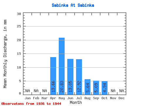
| Statistic | Jan | Feb | Mar | Apr | May | Jun | Jul | Aug | Sep | Oct | Nov | Dec | Annual |
|---|---|---|---|---|---|---|---|---|---|---|---|---|---|
| Mean | 13.67 | 20.85 | 13.04 | 12.91 | 5.66 | 5.07 | 4.94 | ||||||
| Standard Deviation | 5.42 | 10.60 | 9.58 | 11.04 | 4.07 | 3.03 | 2.72 | ||||||
| Min | 9.23 | 10.17 | 5.55 | 1.33 | 0.67 | 0.65 | 0.00 | ||||||
| Max | 20.26 | 41.19 | 36.19 | 31.66 | 13.97 | 10.45 | 8.90 | ||||||
| Coefficient of Variation | 0.40 | 0.51 | 0.73 | 0.85 | 0.72 | 0.60 | 0.55 |
 Return to R-Arctic Net Home Page