|
|
|||||||||||||||||
| Point ID: 8304 | Downloads | Plots | Site Data | Code: 9179 |
|
|
|||||||||||||||||
| Download | |
|---|---|
| Site Descriptor Information | Site Time Series Data |
| Link to all available data | |
| View: | Time Series | All |
| Units: | mm |
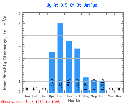
| Statistic | Jan | Feb | Mar | Apr | May | Jun | Jul | Aug | Sep | Oct | Nov | Dec | Annual |
|---|---|---|---|---|---|---|---|---|---|---|---|---|---|
| Mean | 3.54 | 6.03 | 4.52 | 3.86 | 1.34 | 1.15 | 1.02 | ||||||
| Standard Deviation | 0.78 | 1.74 | 1.56 | 2.63 | 0.49 | 0.47 | 0.40 | ||||||
| Min | 2.40 | 3.53 | 2.72 | 0.95 | 0.73 | 0.58 | 0.59 | ||||||
| Max | 4.13 | 8.09 | 6.79 | 7.33 | 1.79 | 1.82 | 1.57 | ||||||
| Coefficient of Variation | 0.22 | 0.29 | 0.34 | 0.68 | 0.37 | 0.41 | 0.39 |
 Return to R-Arctic Net Home Page