|
|
|||||||||||||||||
| Point ID: 8304 | Downloads | Plots | Site Data | Code: 9179 |
|
|
|||||||||||||||||
| Download | |
|---|---|
| Site Descriptor Information | Site Time Series Data |
| Link to all available data | |
| View: | Time Series | All |
| Units: | m3/s |
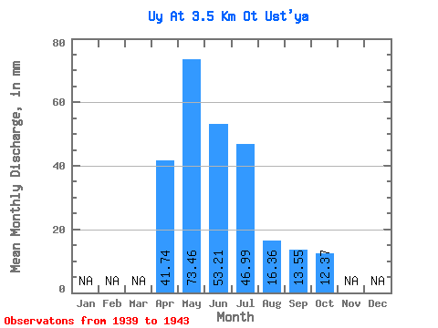
| Statistic | Jan | Feb | Mar | Apr | May | Jun | Jul | Aug | Sep | Oct | Nov | Dec | Annual |
|---|---|---|---|---|---|---|---|---|---|---|---|---|---|
| Mean | 41.74 | 73.45 | 53.21 | 46.99 | 16.36 | 13.55 | 12.37 | ||||||
| Standard Deviation | 9.14 | 21.21 | 18.32 | 32.03 | 6.00 | 5.54 | 4.83 | ||||||
| Min | 28.28 | 42.97 | 32.05 | 11.56 | 8.89 | 6.83 | 7.18 | ||||||
| Max | 48.66 | 98.48 | 80.00 | 89.23 | 21.79 | 21.44 | 19.11 | ||||||
| Coefficient of Variation | 0.22 | 0.29 | 0.34 | 0.68 | 0.37 | 0.41 | 0.39 |
 Return to R-Arctic Net Home Page