|
|
|||||||||||||||||
| Point ID: 8294 | Downloads | Plots | Site Data | Code: 9143 |
|
|
|||||||||||||||||
| Download | |
|---|---|
| Site Descriptor Information | Site Time Series Data |
| Link to all available data | |
| View: | Time Series | All |
| Units: | mm |
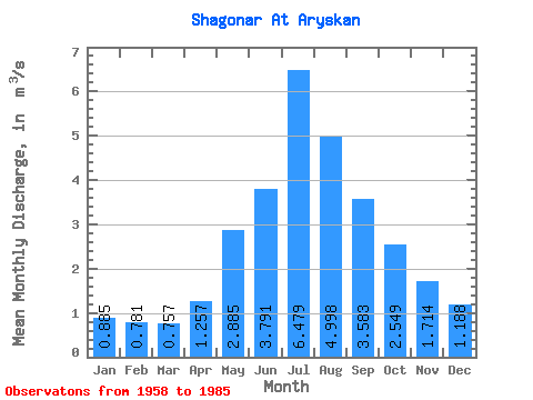
| Statistic | Jan | Feb | Mar | Apr | May | Jun | Jul | Aug | Sep | Oct | Nov | Dec | Annual |
|---|---|---|---|---|---|---|---|---|---|---|---|---|---|
| Mean | 0.89 | 0.78 | 0.76 | 1.26 | 2.88 | 3.79 | 6.48 | 5.00 | 3.58 | 2.55 | 1.71 | 1.19 | 2.59 |
| Standard Deviation | 0.29 | 0.24 | 0.28 | 0.64 | 1.24 | 2.39 | 4.55 | 4.21 | 1.64 | 0.88 | 0.50 | 0.37 | 0.95 |
| Min | 0.40 | 0.44 | 0.45 | -0.61 | 1.23 | 0.00 | 0.39 | 1.39 | 1.22 | 1.03 | 0.93 | 0.56 | 1.17 |
| Max | 1.64 | 1.46 | 1.53 | 3.26 | 5.87 | 10.20 | 15.60 | 23.30 | 9.16 | 4.44 | 2.67 | 1.91 | 4.96 |
| Coefficient of Variation | 0.33 | 0.31 | 0.37 | 0.51 | 0.43 | 0.63 | 0.70 | 0.84 | 0.46 | 0.35 | 0.29 | 0.31 | 0.37 |
 Return to R-Arctic Net Home Page