|
|
|||||||||||||||||
| Point ID: 8294 | Downloads | Plots | Site Data | Code: 9143 |
|
|
|||||||||||||||||
| Download | |
|---|---|
| Site Descriptor Information | Site Time Series Data |
| Link to all available data | |
| View: | Time Series | All |
| Units: | m3/s |
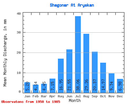
| Statistic | Jan | Feb | Mar | Apr | May | Jun | Jul | Aug | Sep | Oct | Nov | Dec | Annual |
|---|---|---|---|---|---|---|---|---|---|---|---|---|---|
| Mean | 5.20 | 4.18 | 4.45 | 7.14 | 16.94 | 21.55 | 38.05 | 29.35 | 20.37 | 14.97 | 9.74 | 6.98 | 179.45 |
| Standard Deviation | 1.69 | 1.31 | 1.64 | 3.63 | 7.26 | 13.60 | 26.72 | 24.72 | 9.34 | 5.18 | 2.85 | 2.15 | 65.70 |
| Min | 2.35 | 2.35 | 2.64 | -3.47 | 7.22 | 0.00 | 2.29 | 8.16 | 6.94 | 6.05 | 5.29 | 3.29 | 80.98 |
| Max | 9.63 | 7.81 | 8.98 | 18.53 | 34.47 | 57.98 | 91.62 | 136.84 | 52.07 | 26.07 | 15.18 | 11.22 | 343.00 |
| Coefficient of Variation | 0.33 | 0.31 | 0.37 | 0.51 | 0.43 | 0.63 | 0.70 | 0.84 | 0.46 | 0.35 | 0.29 | 0.31 | 0.37 |
 Return to R-Arctic Net Home Page