|
|
|||||||||||||||||
| Point ID: 8291 | Downloads | Plots | Site Data | Code: 9131 |
|
|
|||||||||||||||||
| Download | |
|---|---|
| Site Descriptor Information | Site Time Series Data |
| Link to all available data | |
| View: | Time Series | All |
| Units: | mm |
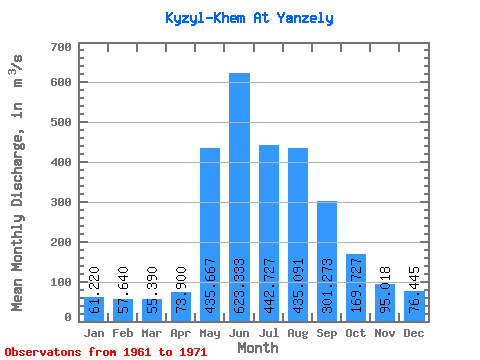
| Statistic | Jan | Feb | Mar | Apr | May | Jun | Jul | Aug | Sep | Oct | Nov | Dec | Annual |
|---|---|---|---|---|---|---|---|---|---|---|---|---|---|
| Mean | 61.22 | 57.64 | 55.39 | 73.90 | 435.67 | 623.33 | 442.73 | 435.09 | 301.27 | 169.73 | 95.02 | 76.44 | 238.73 |
| Standard Deviation | 8.51 | 9.89 | 8.78 | 10.06 | 108.28 | 251.88 | 144.82 | 139.13 | 45.22 | 30.77 | 16.00 | 16.23 | 45.10 |
| Min | 52.30 | 49.20 | 42.80 | 58.30 | 252.00 | 361.00 | 256.00 | 220.00 | 249.00 | 128.00 | 61.00 | 55.90 | 182.29 |
| Max | 77.60 | 81.50 | 75.50 | 87.20 | 591.00 | 1230.00 | 703.00 | 612.00 | 383.00 | 230.00 | 118.00 | 117.00 | 333.89 |
| Coefficient of Variation | 0.14 | 0.17 | 0.16 | 0.14 | 0.25 | 0.40 | 0.33 | 0.32 | 0.15 | 0.18 | 0.17 | 0.21 | 0.19 |
 Return to R-Arctic Net Home Page