|
|
|||||||||||||||||
| Point ID: 8291 | Downloads | Plots | Site Data | Code: 9131 |
|
|
|||||||||||||||||
| Download | |
|---|---|
| Site Descriptor Information | Site Time Series Data |
| Link to all available data | |
| View: | Time Series | All |
| Units: | m3/s |
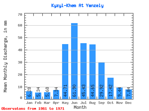
| Statistic | Jan | Feb | Mar | Apr | May | Jun | Jul | Aug | Sep | Oct | Nov | Dec | Annual |
|---|---|---|---|---|---|---|---|---|---|---|---|---|---|
| Mean | 6.28 | 5.39 | 5.68 | 7.34 | 44.70 | 61.90 | 45.43 | 44.64 | 29.92 | 17.41 | 9.44 | 7.84 | 288.67 |
| Standard Deviation | 0.87 | 0.93 | 0.90 | 1.00 | 11.11 | 25.02 | 14.86 | 14.28 | 4.49 | 3.16 | 1.59 | 1.67 | 54.53 |
| Min | 5.37 | 4.60 | 4.39 | 5.79 | 25.86 | 35.85 | 26.27 | 22.57 | 24.73 | 13.13 | 6.06 | 5.74 | 220.43 |
| Max | 7.96 | 7.62 | 7.75 | 8.66 | 60.64 | 122.15 | 72.13 | 62.79 | 38.04 | 23.60 | 11.72 | 12.01 | 403.74 |
| Coefficient of Variation | 0.14 | 0.17 | 0.16 | 0.14 | 0.25 | 0.40 | 0.33 | 0.32 | 0.15 | 0.18 | 0.17 | 0.21 | 0.19 |
 Return to R-Arctic Net Home Page