|
|
|||||||||||||||||
| Point ID: 8290 | Downloads | Plots | Site Data | Code: 9129 |
|
|
|||||||||||||||||
| Download | |
|---|---|
| Site Descriptor Information | Site Time Series Data |
| Link to all available data | |
| View: | Time Series | All |
| Units: | mm |
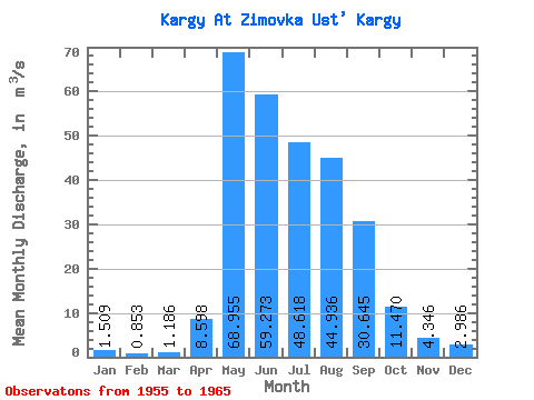
| Statistic | Jan | Feb | Mar | Apr | May | Jun | Jul | Aug | Sep | Oct | Nov | Dec | Annual |
|---|---|---|---|---|---|---|---|---|---|---|---|---|---|
| Mean | 1.51 | 0.85 | 1.19 | 8.60 | 68.95 | 59.27 | 48.62 | 44.94 | 30.64 | 11.47 | 4.35 | 2.99 | 23.60 |
| Standard Deviation | 0.74 | 0.35 | 0.40 | 5.40 | 18.68 | 23.33 | 18.79 | 25.88 | 10.86 | 2.01 | 1.09 | 0.91 | 5.24 |
| Min | 0.53 | 0.45 | 0.55 | 3.21 | 44.60 | 27.60 | 20.40 | 14.50 | 17.80 | 7.28 | 2.47 | 1.76 | 16.27 |
| Max | 2.70 | 1.48 | 1.73 | 22.60 | 108.00 | 94.70 | 83.60 | 90.10 | 56.60 | 14.80 | 6.04 | 4.30 | 33.84 |
| Coefficient of Variation | 0.49 | 0.41 | 0.34 | 0.63 | 0.27 | 0.39 | 0.39 | 0.58 | 0.35 | 0.17 | 0.25 | 0.30 | 0.22 |
 Return to R-Arctic Net Home Page