|
|
|||||||||||||||||
| Point ID: 8290 | Downloads | Plots | Site Data | Code: 9129 |
|
|
|||||||||||||||||
| Download | |
|---|---|
| Site Descriptor Information | Site Time Series Data |
| Link to all available data | |
| View: | Time Series | All |
| Units: | m3/s |
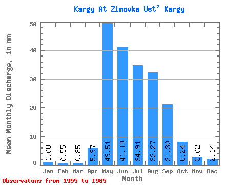
| Statistic | Jan | Feb | Mar | Apr | May | Jun | Jul | Aug | Sep | Oct | Nov | Dec | Annual |
|---|---|---|---|---|---|---|---|---|---|---|---|---|---|
| Mean | 1.08 | 0.56 | 0.85 | 5.97 | 49.51 | 41.19 | 34.91 | 32.26 | 21.30 | 8.23 | 3.02 | 2.14 | 199.71 |
| Standard Deviation | 0.53 | 0.23 | 0.28 | 3.75 | 13.41 | 16.21 | 13.49 | 18.58 | 7.54 | 1.44 | 0.76 | 0.65 | 44.33 |
| Min | 0.38 | 0.29 | 0.40 | 2.23 | 32.02 | 19.18 | 14.65 | 10.41 | 12.37 | 5.23 | 1.72 | 1.26 | 137.65 |
| Max | 1.94 | 0.97 | 1.24 | 15.71 | 77.54 | 65.81 | 60.02 | 64.69 | 39.33 | 10.63 | 4.20 | 3.09 | 286.35 |
| Coefficient of Variation | 0.49 | 0.41 | 0.34 | 0.63 | 0.27 | 0.39 | 0.39 | 0.58 | 0.35 | 0.17 | 0.25 | 0.30 | 0.22 |
 Return to R-Arctic Net Home Page