|
|
|||||||||||||||||
| Point ID: 8270 | Downloads | Plots | Site Data | Code: 8386 |
|
|
|||||||||||||||||
| Download | |
|---|---|
| Site Descriptor Information | Site Time Series Data |
| Link to all available data | |
| View: | Time Series | All |
| Units: | mm |
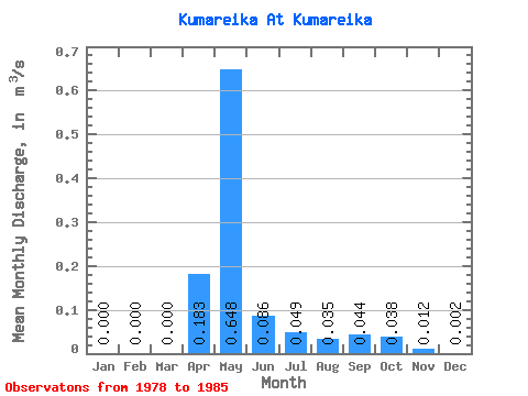
| Statistic | Jan | Feb | Mar | Apr | May | Jun | Jul | Aug | Sep | Oct | Nov | Dec | Annual |
|---|---|---|---|---|---|---|---|---|---|---|---|---|---|
| Mean | 0.00 | 0.00 | 0.00 | 0.18 | 0.65 | 0.09 | 0.05 | 0.04 | 0.04 | 0.04 | 0.01 | 0.00 | 0.09 |
| Standard Deviation | 0.00 | 0.00 | 0.00 | 0.14 | 0.34 | 0.04 | 0.02 | 0.02 | 0.02 | 0.02 | 0.01 | 0.01 | 0.02 |
| Min | 0.00 | 0.00 | 0.00 | 0.07 | 0.21 | 0.02 | 0.02 | 0.01 | 0.02 | 0.02 | 0.00 | 0.00 | 0.06 |
| Max | 0.00 | 0.00 | 0.00 | 0.43 | 1.31 | 0.13 | 0.07 | 0.06 | 0.08 | 0.06 | 0.05 | 0.01 | 0.14 |
| Coefficient of Variation | 0.74 | 0.52 | 0.46 | 0.38 | 0.50 | 0.52 | 0.44 | 1.23 | 2.83 | 0.25 |
 Return to R-Arctic Net Home Page