|
|
|||||||||||||||||
| Point ID: 8270 | Downloads | Plots | Site Data | Code: 8386 |
|
|
|||||||||||||||||
| Download | |
|---|---|
| Site Descriptor Information | Site Time Series Data |
| Link to all available data | |
| View: | Time Series | All |
| Units: | m3/s |
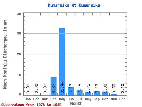
| Statistic | Jan | Feb | Mar | Apr | May | Jun | Jul | Aug | Sep | Oct | Nov | Dec | Annual |
|---|---|---|---|---|---|---|---|---|---|---|---|---|---|
| Mean | 0.00 | 0.00 | 0.00 | 8.87 | 32.46 | 4.19 | 2.45 | 1.75 | 2.13 | 1.90 | 0.58 | 0.08 | 54.06 |
| Standard Deviation | 0.00 | 0.00 | 0.00 | 6.60 | 16.76 | 1.92 | 0.93 | 0.87 | 1.11 | 0.83 | 0.72 | 0.23 | 13.56 |
| Min | 0.00 | 0.00 | 0.00 | 3.20 | 10.51 | 0.92 | 1.05 | 0.60 | 0.87 | 0.90 | 0.05 | 0.00 | 37.02 |
| Max | 0.00 | 0.00 | 0.00 | 20.83 | 65.57 | 6.15 | 3.65 | 3.05 | 3.92 | 2.90 | 2.23 | 0.65 | 80.42 |
| Coefficient of Variation | 0.74 | 0.52 | 0.46 | 0.38 | 0.50 | 0.52 | 0.44 | 1.23 | 2.83 | 0.25 |
 Return to R-Arctic Net Home Page