|
|
|||||||||||||||||
| Point ID: 8266 | Downloads | Plots | Site Data | Code: 8378 |
|
|
|||||||||||||||||
| Download | |
|---|---|
| Site Descriptor Information | Site Time Series Data |
| Link to all available data | |
| View: | Time Series | All |
| Units: | mm |
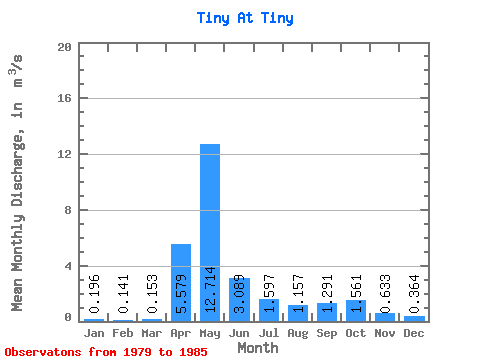
| Statistic | Jan | Feb | Mar | Apr | May | Jun | Jul | Aug | Sep | Oct | Nov | Dec | Annual |
|---|---|---|---|---|---|---|---|---|---|---|---|---|---|
| Mean | 0.20 | 0.14 | 0.15 | 5.58 | 12.71 | 3.09 | 1.60 | 1.16 | 1.29 | 1.56 | 0.63 | 0.36 | 2.37 |
| Standard Deviation | 0.15 | 0.10 | 0.08 | 4.18 | 6.51 | 1.87 | 0.96 | 1.02 | 0.56 | 0.98 | 0.35 | 0.25 | 0.51 |
| Min | 0.00 | 0.00 | 0.00 | 0.75 | 4.44 | 1.27 | 0.56 | 0.62 | 0.45 | 0.65 | 0.29 | 0.11 | 1.96 |
| Max | 0.47 | 0.31 | 0.26 | 12.60 | 25.00 | 6.56 | 3.44 | 3.46 | 2.24 | 3.48 | 1.13 | 0.71 | 3.33 |
| Coefficient of Variation | 0.75 | 0.69 | 0.53 | 0.75 | 0.51 | 0.61 | 0.60 | 0.89 | 0.44 | 0.63 | 0.55 | 0.69 | 0.21 |
 Return to R-Arctic Net Home Page