|
|
|||||||||||||||||
| Point ID: 8266 | Downloads | Plots | Site Data | Code: 8378 |
|
|
|||||||||||||||||
| Download | |
|---|---|
| Site Descriptor Information | Site Time Series Data |
| Link to all available data | |
| View: | Time Series | All |
| Units: | m3/s |
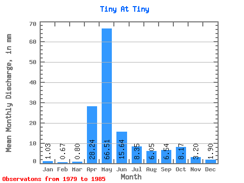
| Statistic | Jan | Feb | Mar | Apr | May | Jun | Jul | Aug | Sep | Oct | Nov | Dec | Annual |
|---|---|---|---|---|---|---|---|---|---|---|---|---|---|
| Mean | 1.02 | 0.67 | 0.80 | 28.24 | 66.50 | 15.64 | 8.35 | 6.05 | 6.54 | 8.17 | 3.20 | 1.91 | 146.27 |
| Standard Deviation | 0.77 | 0.46 | 0.42 | 21.18 | 34.07 | 9.48 | 5.04 | 5.36 | 2.85 | 5.14 | 1.76 | 1.31 | 31.35 |
| Min | 0.00 | 0.00 | 0.00 | 3.80 | 23.22 | 6.43 | 2.93 | 3.24 | 2.28 | 3.40 | 1.47 | 0.57 | 120.92 |
| Max | 2.46 | 1.48 | 1.36 | 63.79 | 130.76 | 33.21 | 17.99 | 18.10 | 11.34 | 18.20 | 5.72 | 3.71 | 205.52 |
| Coefficient of Variation | 0.75 | 0.69 | 0.53 | 0.75 | 0.51 | 0.61 | 0.60 | 0.89 | 0.44 | 0.63 | 0.55 | 0.69 | 0.21 |
 Return to R-Arctic Net Home Page