|
|
|||||||||||||||||
| Point ID: 8260 | Downloads | Plots | Site Data | Code: 8367 |
|
|
|||||||||||||||||
| Download | |
|---|---|
| Site Descriptor Information | Site Time Series Data |
| Link to all available data | |
| View: | Time Series | All |
| Units: | mm |
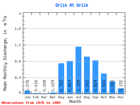
| Statistic | Jan | Feb | Mar | Apr | May | Jun | Jul | Aug | Sep | Oct | Nov | Dec | Annual |
|---|---|---|---|---|---|---|---|---|---|---|---|---|---|
| Mean | 0.07 | 0.02 | 0.01 | 0.03 | 0.75 | 0.81 | 1.16 | 0.91 | 0.82 | 0.50 | 0.30 | 0.13 | 0.47 |
| Standard Deviation | 0.09 | 0.03 | 0.02 | 0.09 | 0.42 | 0.34 | 1.05 | 0.43 | 0.39 | 0.14 | 0.08 | 0.05 | 0.15 |
| Min | 0.00 | 0.00 | 0.00 | 0.00 | 0.29 | 0.33 | 0.27 | 0.43 | 0.37 | 0.32 | 0.16 | 0.03 | 0.29 |
| Max | 0.29 | 0.07 | 0.07 | 0.26 | 1.32 | 1.44 | 3.29 | 1.81 | 1.42 | 0.71 | 0.41 | 0.20 | 0.73 |
| Coefficient of Variation | 1.18 | 1.60 | 3.00 | 3.00 | 0.55 | 0.42 | 0.91 | 0.47 | 0.48 | 0.27 | 0.28 | 0.40 | 0.32 |
 Return to R-Arctic Net Home Page