|
|
|||||||||||||||||
| Point ID: 8260 | Downloads | Plots | Site Data | Code: 8367 |
|
|
|||||||||||||||||
| Download | |
|---|---|
| Site Descriptor Information | Site Time Series Data |
| Link to all available data | |
| View: | Time Series | All |
| Units: | m3/s |
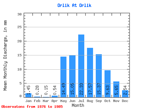
| Statistic | Jan | Feb | Mar | Apr | May | Jun | Jul | Aug | Sep | Oct | Nov | Dec | Annual |
|---|---|---|---|---|---|---|---|---|---|---|---|---|---|
| Mean | 1.45 | 0.29 | 0.15 | 0.54 | 14.49 | 15.04 | 22.33 | 17.57 | 15.37 | 9.63 | 5.65 | 2.54 | 107.63 |
| Standard Deviation | 1.71 | 0.46 | 0.46 | 1.62 | 8.03 | 6.36 | 20.22 | 8.22 | 7.33 | 2.60 | 1.56 | 1.01 | 34.09 |
| Min | 0.00 | 0.00 | 0.00 | 0.00 | 5.59 | 6.15 | 5.20 | 8.28 | 6.90 | 6.17 | 2.98 | 0.52 | 66.22 |
| Max | 5.59 | 1.18 | 1.37 | 4.85 | 25.43 | 26.85 | 63.39 | 34.87 | 26.48 | 13.68 | 7.64 | 3.85 | 165.22 |
| Coefficient of Variation | 1.18 | 1.60 | 3.00 | 3.00 | 0.55 | 0.42 | 0.91 | 0.47 | 0.48 | 0.27 | 0.28 | 0.40 | 0.32 |
 Return to R-Arctic Net Home Page