|
|
|||||||||||||||||
| Point ID: 8258 | Downloads | Plots | Site Data | Code: 8359 |
|
|
|||||||||||||||||
| Download | |
|---|---|
| Site Descriptor Information | Site Time Series Data |
| Link to all available data | |
| View: | Time Series | All |
| Units: | mm |
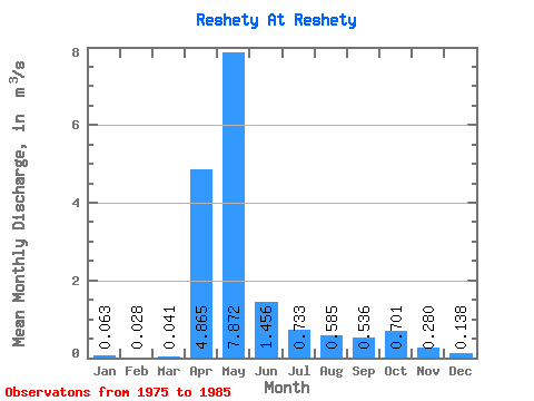
| Statistic | Jan | Feb | Mar | Apr | May | Jun | Jul | Aug | Sep | Oct | Nov | Dec | Annual |
|---|---|---|---|---|---|---|---|---|---|---|---|---|---|
| Mean | 0.06 | 0.03 | 0.04 | 4.87 | 7.87 | 1.46 | 0.73 | 0.58 | 0.54 | 0.70 | 0.28 | 0.14 | 1.41 |
| Standard Deviation | 0.06 | 0.04 | 0.07 | 3.94 | 3.76 | 0.99 | 0.58 | 0.59 | 0.25 | 0.58 | 0.20 | 0.13 | 0.47 |
| Min | 0.00 | 0.00 | 0.00 | 0.66 | 1.74 | 0.39 | 0.27 | 0.22 | 0.22 | 0.20 | 0.03 | 0.00 | 0.44 |
| Max | 0.16 | 0.10 | 0.20 | 12.80 | 15.80 | 4.00 | 2.36 | 2.34 | 0.94 | 2.09 | 0.65 | 0.38 | 1.89 |
| Coefficient of Variation | 1.00 | 1.37 | 1.77 | 0.81 | 0.48 | 0.68 | 0.80 | 1.02 | 0.47 | 0.82 | 0.73 | 0.94 | 0.33 |
 Return to R-Arctic Net Home Page