|
|
|||||||||||||||||
| Point ID: 8258 | Downloads | Plots | Site Data | Code: 8359 |
|
|
|||||||||||||||||
| Download | |
|---|---|
| Site Descriptor Information | Site Time Series Data |
| Link to all available data | |
| View: | Time Series | All |
| Units: | m3/s |
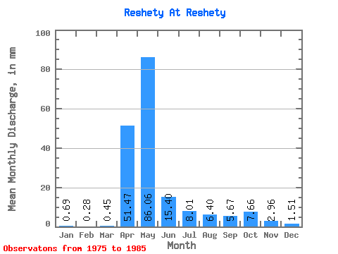
| Statistic | Jan | Feb | Mar | Apr | May | Jun | Jul | Aug | Sep | Oct | Nov | Dec | Annual |
|---|---|---|---|---|---|---|---|---|---|---|---|---|---|
| Mean | 0.69 | 0.28 | 0.45 | 51.47 | 86.04 | 15.41 | 8.01 | 6.39 | 5.67 | 7.66 | 2.96 | 1.51 | 181.99 |
| Standard Deviation | 0.69 | 0.38 | 0.80 | 41.64 | 41.06 | 10.46 | 6.38 | 6.50 | 2.68 | 6.30 | 2.16 | 1.42 | 60.81 |
| Min | 0.00 | 0.00 | 0.00 | 6.98 | 19.02 | 4.13 | 2.95 | 2.41 | 2.33 | 2.19 | 0.30 | 0.00 | 57.00 |
| Max | 1.75 | 0.96 | 2.19 | 135.42 | 172.70 | 42.32 | 25.80 | 25.58 | 9.95 | 22.84 | 6.88 | 4.15 | 243.92 |
| Coefficient of Variation | 1.00 | 1.37 | 1.77 | 0.81 | 0.48 | 0.68 | 0.80 | 1.02 | 0.47 | 0.82 | 0.73 | 0.94 | 0.33 |
 Return to R-Arctic Net Home Page