|
|
|||||||||||||||||
| Point ID: 8250 | Downloads | Plots | Site Data | Code: 8337 |
|
|
|||||||||||||||||
| Download | |
|---|---|
| Site Descriptor Information | Site Time Series Data |
| Link to all available data | |
| View: | Time Series | All |
| Units: | mm |
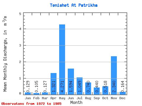
| Statistic | Jan | Feb | Mar | Apr | May | Jun | Jul | Aug | Sep | Oct | Nov | Dec | Annual |
|---|---|---|---|---|---|---|---|---|---|---|---|---|---|
| Mean | 0.13 | 0.10 | 0.13 | 1.32 | 4.27 | 1.59 | 1.05 | 0.74 | 0.44 | 0.52 | 2.34 | 0.16 | 0.91 |
| Standard Deviation | 0.15 | 0.14 | 0.14 | 1.22 | 1.49 | 0.76 | 0.45 | 0.69 | 0.25 | 0.28 | 7.41 | 0.08 | 0.17 |
| Min | 0.03 | 0.01 | 0.00 | 0.36 | 2.22 | 0.85 | 0.45 | 0.25 | 0.11 | 0.24 | 0.10 | 0.05 | 0.65 |
| Max | 0.56 | 0.52 | 0.53 | 4.54 | 7.09 | 3.30 | 2.10 | 2.75 | 0.89 | 1.29 | 27.00 | 0.28 | 1.10 |
| Coefficient of Variation | 1.14 | 1.29 | 1.12 | 0.93 | 0.35 | 0.48 | 0.43 | 0.94 | 0.58 | 0.54 | 3.17 | 0.49 | 0.19 |
 Return to R-Arctic Net Home Page