|
|
|||||||||||||||||
| Point ID: 8250 | Downloads | Plots | Site Data | Code: 8337 |
|
|
|||||||||||||||||
| Download | |
|---|---|
| Site Descriptor Information | Site Time Series Data |
| Link to all available data | |
| View: | Time Series | All |
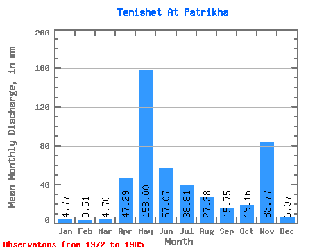
| Units: | m3/s |
| Statistic | Jan | Feb | Mar | Apr | May | Jun | Jul | Aug | Sep | Oct | Nov | Dec | Annual |
|---|---|---|---|---|---|---|---|---|---|---|---|---|---|
| Mean | 4.78 | 3.54 | 4.72 | 47.29 | 157.97 | 57.05 | 38.80 | 27.37 | 15.75 | 19.18 | 83.78 | 6.08 | 394.69 |
| Standard Deviation | 5.43 | 4.58 | 5.27 | 43.80 | 55.26 | 27.32 | 16.77 | 25.59 | 9.07 | 10.31 | 265.31 | 3.00 | 76.47 |
| Min | 1.04 | 0.44 | 0.00 | 12.89 | 82.11 | 30.43 | 16.64 | 9.25 | 3.94 | 8.88 | 3.58 | 1.92 | 284.94 |
| Max | 20.71 | 17.52 | 19.60 | 162.54 | 262.27 | 118.14 | 77.68 | 101.72 | 31.86 | 47.72 | 966.66 | 10.36 | 480.08 |
| Coefficient of Variation | 1.14 | 1.29 | 1.12 | 0.93 | 0.35 | 0.48 | 0.43 | 0.94 | 0.58 | 0.54 | 3.17 | 0.49 | 0.19 |
 Return to R-Arctic Net Home Page