|
|
|||||||||||||||||
| Point ID: 8241 | Downloads | Plots | Site Data | Code: 8314 |
|
|
|||||||||||||||||
| Download | |
|---|---|
| Site Descriptor Information | Site Time Series Data |
| Link to all available data | |
| View: | Time Series | All |
| Units: | mm |
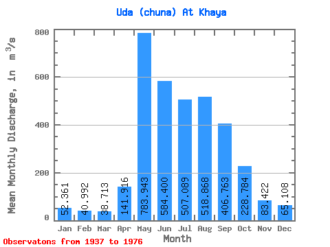
| Statistic | Jan | Feb | Mar | Apr | May | Jun | Jul | Aug | Sep | Oct | Nov | Dec | Annual |
|---|---|---|---|---|---|---|---|---|---|---|---|---|---|
| Mean | 52.36 | 40.99 | 38.71 | 141.92 | 783.94 | 584.40 | 507.09 | 518.87 | 406.76 | 228.78 | 83.42 | 65.11 | 289.56 |
| Standard Deviation | 9.91 | 8.02 | 8.17 | 128.15 | 223.33 | 158.88 | 160.63 | 170.95 | 163.16 | 74.48 | 18.08 | 10.05 | 53.52 |
| Min | 30.80 | 23.80 | 22.40 | 22.00 | 423.00 | 381.00 | 65.30 | 338.00 | 266.00 | 158.00 | 51.20 | 45.50 | 208.40 |
| Max | 77.10 | 63.20 | 59.70 | 537.00 | 1290.00 | 1070.00 | 882.00 | 1150.00 | 1120.00 | 602.00 | 147.00 | 86.60 | 509.96 |
| Coefficient of Variation | 0.19 | 0.20 | 0.21 | 0.90 | 0.28 | 0.27 | 0.32 | 0.33 | 0.40 | 0.33 | 0.22 | 0.15 | 0.18 |
 Return to R-Arctic Net Home Page