|
|
|||||||||||||||||
| Point ID: 8241 | Downloads | Plots | Site Data | Code: 8314 |
|
|
|||||||||||||||||
| Download | |
|---|---|
| Site Descriptor Information | Site Time Series Data |
| Link to all available data | |
| View: | Time Series | All |
| Units: | m3/s |
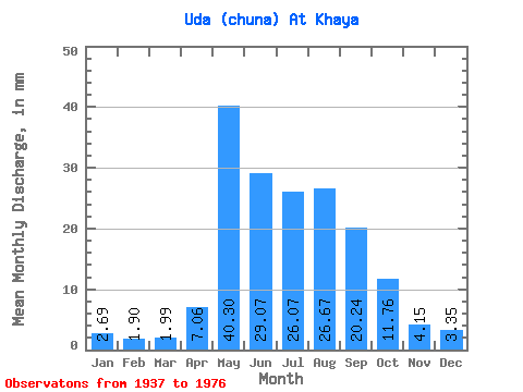
| Statistic | Jan | Feb | Mar | Apr | May | Jun | Jul | Aug | Sep | Oct | Nov | Dec | Annual |
|---|---|---|---|---|---|---|---|---|---|---|---|---|---|
| Mean | 2.69 | 1.92 | 1.99 | 7.06 | 40.30 | 29.07 | 26.07 | 26.67 | 20.24 | 11.76 | 4.15 | 3.35 | 175.40 |
| Standard Deviation | 0.51 | 0.38 | 0.42 | 6.38 | 11.48 | 7.90 | 8.26 | 8.79 | 8.12 | 3.83 | 0.90 | 0.52 | 32.42 |
| Min | 1.58 | 1.11 | 1.15 | 1.09 | 21.74 | 18.95 | 3.36 | 17.37 | 13.23 | 8.12 | 2.55 | 2.34 | 126.24 |
| Max | 3.96 | 2.96 | 3.07 | 26.72 | 66.31 | 53.23 | 45.34 | 59.11 | 55.72 | 30.94 | 7.31 | 4.45 | 308.91 |
| Coefficient of Variation | 0.19 | 0.20 | 0.21 | 0.90 | 0.28 | 0.27 | 0.32 | 0.33 | 0.40 | 0.33 | 0.22 | 0.15 | 0.18 |
 Return to R-Arctic Net Home Page