|
|
|||||||||||||||||
| Point ID: 8228 | Downloads | Plots | Site Data | Code: 8273 |
|
|
|||||||||||||||||
| Download | |
|---|---|
| Site Descriptor Information | Site Time Series Data |
| Link to all available data | |
| View: | Time Series | All |
| Units: | mm |
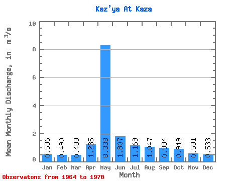
| Statistic | Jan | Feb | Mar | Apr | May | Jun | Jul | Aug | Sep | Oct | Nov | Dec | Annual |
|---|---|---|---|---|---|---|---|---|---|---|---|---|---|
| Mean | 0.54 | 0.49 | 0.49 | 1.23 | 8.34 | 1.81 | 1.17 | 1.05 | 0.98 | 0.92 | 0.59 | 0.53 | 1.48 |
| Standard Deviation | 0.19 | 0.27 | 0.26 | 1.25 | 2.02 | 0.75 | 0.21 | 0.23 | 0.17 | 0.20 | 0.13 | 0.16 | 0.26 |
| Min | 0.19 | 0.00 | 0.00 | 0.08 | 6.06 | 1.22 | 0.84 | 0.80 | 0.73 | 0.71 | 0.42 | 0.35 | 1.24 |
| Max | 0.77 | 0.84 | 0.78 | 3.87 | 11.80 | 3.31 | 1.46 | 1.46 | 1.26 | 1.29 | 0.78 | 0.76 | 1.97 |
| Coefficient of Variation | 0.35 | 0.56 | 0.53 | 1.01 | 0.24 | 0.41 | 0.18 | 0.22 | 0.17 | 0.22 | 0.22 | 0.30 | 0.18 |
 Return to R-Arctic Net Home Page