|
|
|||||||||||||||||
| Point ID: 8228 | Downloads | Plots | Site Data | Code: 8273 |
|
|
|||||||||||||||||
| Download | |
|---|---|
| Site Descriptor Information | Site Time Series Data |
| Link to all available data | |
| View: | Time Series | All |
| Units: | m3/s |
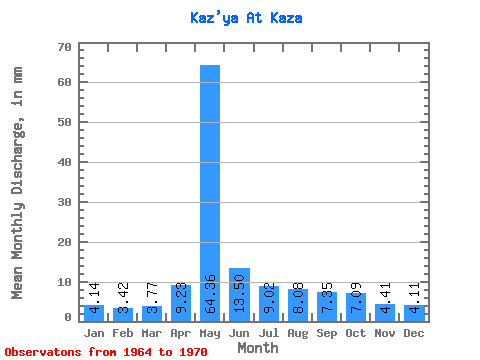
| Statistic | Jan | Feb | Mar | Apr | May | Jun | Jul | Aug | Sep | Oct | Nov | Dec | Annual |
|---|---|---|---|---|---|---|---|---|---|---|---|---|---|
| Mean | 4.13 | 3.45 | 3.77 | 9.23 | 64.35 | 13.50 | 9.02 | 8.08 | 7.35 | 7.09 | 4.42 | 4.11 | 134.95 |
| Standard Deviation | 1.46 | 1.92 | 1.99 | 9.32 | 15.58 | 5.60 | 1.61 | 1.80 | 1.25 | 1.56 | 0.98 | 1.24 | 23.84 |
| Min | 1.47 | 0.00 | 0.00 | 0.58 | 46.77 | 9.11 | 6.48 | 6.17 | 5.45 | 5.48 | 3.14 | 2.70 | 113.07 |
| Max | 5.94 | 5.91 | 6.02 | 28.91 | 91.07 | 24.73 | 11.27 | 11.27 | 9.41 | 9.96 | 5.83 | 5.87 | 179.48 |
| Coefficient of Variation | 0.35 | 0.56 | 0.53 | 1.01 | 0.24 | 0.41 | 0.18 | 0.22 | 0.17 | 0.22 | 0.22 | 0.30 | 0.18 |
 Return to R-Arctic Net Home Page