|
|
|||||||||||||||||
| Point ID: 82 | Downloads | Plots | Site Data | Code: 05AD001 |
|
|
|||||||||||||||||
| Download | |
|---|---|
| Site Descriptor Information | Site Time Series Data |
| Link to all available data | |
| View: | Time Series | All |
| Units: | mm |
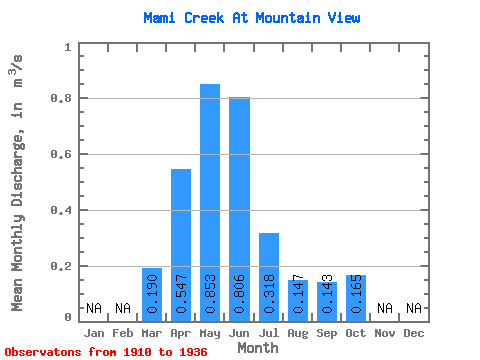
| Statistic | Jan | Feb | Mar | Apr | May | Jun | Jul | Aug | Sep | Oct | Nov | Dec | Annual |
|---|---|---|---|---|---|---|---|---|---|---|---|---|---|
| Mean | 0.19 | 0.55 | 0.85 | 0.81 | 0.32 | 0.15 | 0.14 | 0.17 | |||||
| Standard Deviation | 0.33 | 0.49 | 1.49 | 1.22 | 0.43 | 0.22 | 0.25 | 0.23 | |||||
| Min | 0.00 | 0.04 | 0.02 | 0.09 | 0.01 | 0.00 | 0.01 | 0.01 | |||||
| Max | 1.12 | 1.72 | 6.29 | 4.49 | 1.19 | 0.79 | 0.99 | 0.77 | |||||
| Coefficient of Variation | 1.73 | 0.90 | 1.75 | 1.52 | 1.35 | 1.48 | 1.78 | 1.38 |
 Return to R-Arctic Net Home Page