|
|
|||||||||||||||||
| Point ID: 82 | Downloads | Plots | Site Data | Code: 05AD001 |
|
|
|||||||||||||||||
| Download | |
|---|---|
| Site Descriptor Information | Site Time Series Data |
| Link to all available data | |
| View: | Time Series | All |
| Units: | m3/s |
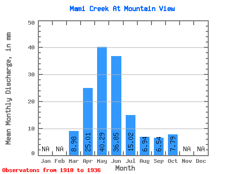
| Statistic | Jan | Feb | Mar | Apr | May | Jun | Jul | Aug | Sep | Oct | Nov | Dec | Annual |
|---|---|---|---|---|---|---|---|---|---|---|---|---|---|
| Mean | 8.96 | 24.98 | 40.30 | 36.83 | 15.00 | 6.94 | 6.52 | 7.78 | |||||
| Standard Deviation | 15.52 | 22.59 | 70.43 | 55.79 | 20.24 | 10.26 | 11.60 | 10.74 | |||||
| Min | 0.09 | 1.92 | 0.94 | 3.98 | 0.24 | 0.00 | 0.37 | 0.61 | |||||
| Max | 52.90 | 78.63 | 297.08 | 205.26 | 56.20 | 37.50 | 45.12 | 36.23 | |||||
| Coefficient of Variation | 1.73 | 0.90 | 1.75 | 1.52 | 1.35 | 1.48 | 1.78 | 1.38 |
 Return to R-Arctic Net Home Page